Wednesday, October 4, 2017

Day 20 - Normandy (Le Havre), France


7am. Time to head out. 10-hour day ahead of us. The plan today is to visit the main landing points within France of WW2. 2-hour drive each way to the war theater. Let's head out.
The bridge which will take us into Normandy
You can see the line where the Atlantic Ocean mixes with the Seine river
Stop 1
The previous photo was taken in this exact spot
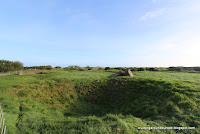
Holes remain where the Armed Forces shelled the island trying to take out their guns
The Germans were too dug in and the shelling didn't matter much as extensive tunnels connected all bunkers
Example of how strong the structures were
One of the four 152mm gun houses
Built so well even the shelling onto the beach had little affect on the structure
These buildings were to survive anything
Walking down into one of the shooting galleries
A tiny peep hole at the bottom of the stairway ensured they could fire on anyone coming to them from the rear
Perfect setup to shoot anyone landing on the beach or trying to scale the cliff walls below, all without risking getting shot themselves
Exterior view of the prior pic
Eventually these were firebombed to kill anyone inside by the Allied troops
The cliffs the US forces scaled to try to get access to the German troops. It's amazing anyone survived

Remains of the gun housing

On our way to the beaches of Normandy, France.
Before the American Cemetery was built many US troops were buried all over the countryside, then moved in the 1950's
Normandy
The 5-miles of open, flat, exposed Normandy beach the troops had to clear before reaching the mainland
With the German troops dug into the hills above this beach it's amazing anyone reached the land


The American Cemetery on Normandy
Beautiful farm house upon entering the property
172 aces
On the white wall in the rear are the names of those Americans that died but their bodies were never found / identified
A black dot notates the remains have been identified since the wall creation. In total 16 have been identified of the 1557 names.
Map showing how troops were deployed from England into Normandy
All the troops converged on the 5-miles of Normandy beaches
Imagine seeing all the equipment and people all over the horizon
There are 8 similar viewpoints to this in the cemetery
Statues looking out for the fallen troops
Not going to lie, this visit made me cry twice due to the design and vastness of the headstones. It's emotionally more moving than Arlington.

So eventually the Allied forces needed supplies and they didn't occupy the deep harbors in France. What did they do? Of course they made their own supply channel. Barges were made in secret in England and towed across the channel before being moored into this spot.
Bridges traversed each mooring (like the one below)
Imagine the top three photos made this structure happen
Bridges lead up to the town and into France
One of the mooring bridges
Most of these buildings survived the war though much of the area was destroyed
Shipping container art back at port
Emotionally this was a draining day. To see how the Germans were setup to own Europe yet some how the Allied forces had a few lucky breaks and that was enough to end the war, with significant human loss, hit home more than any school textbook could have instilled. If you're ever in Northwest France you need to make time to visit and experience this place yourself.

Today is the end of the first cruise. Tomorrow - new trip begins, time to head to the cooler north.

No comments:

Post a Comment